


Plans for Ulu Pandan revised: A third of Dover Forest set aside for public housing, nature park to be established
Plans for the development of an Ulu Pandan site have been revised following feedback from nature groups and the public, as well as findings from environmental studies.


SINGAPORE: Plans for the development of an Ulu Pandan site have been revised following feedback from nature groups and the public, as well as findings from environmental studies.
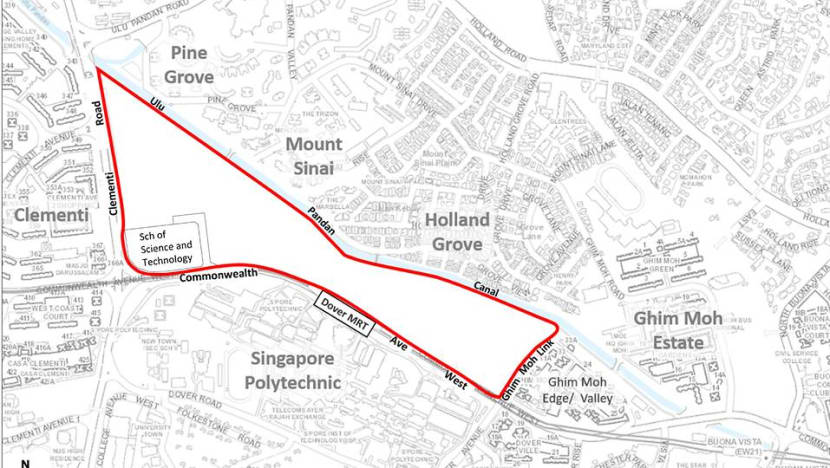
The 33ha Ulu Pandan estate is where Dover Forest is located. Zoned for residential development since 2003, authorities had announced last December that Build-to-Order (BTO) flats in the area will be launched for sale this year.
That prompted nature groups to raise concerns about developments, citing the need to protect animal and plant species.
READ: The Dover Forest debate: Can nature and development co-exist in urbanised Singapore?
On Friday (Jul 30), the Housing & Development Board (HDB) said that 11ha or one-third of the land, located in the eastern side of Ulu Pandan, will be set aside for public housing in the immediate term. The first of those new flats is expected to be launched in the second half of 2022.
This is to meet the “strong housing demand in mature estates, including from young families who want to live near their parents in the area for better mutual care and support”, said HDB in a media release.
“HDB is also proposing to set aside approximately 5ha of greenery on the eastern side of the site and along the canal for park and recreational use,” the agency said.
NATURE PARK IN WESTERN HALF, OTHER PLANS DEFERRED
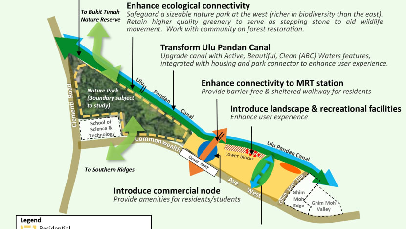
On the western half of the Ulu Pandan site, a “sizeable” nature park will be established.
Development plans for the western half - after Dover MRT station to Clementi Road - will also be “put off in the medium term” and reviewed again in about a decade, said the Housing Board.
“Agencies will continue to study and revisit the plans for the site sometime around 2030, taking into consideration Singapore’s land use needs at that time.”
The nature park will serve as an ecological connector and habitat between Clementi Forest and the Southern Ridges. It will also complement the connectivity along the Rail Corridor in the vicinity of Ulu Pandan, said HDB.
“Agencies are studying the optimal size and boundary of the nature park, and will subsequently work with the community to carry out forest restoration and habitat enhancement works to strengthen the area’s ecological resilience,” it added.
The nature park will be linked to the new Clementi Nature Corridor, which was announced by the National Parks Board (NParks) on Friday.
READ: New nature corridor for wildlife identified in Clementi for ecological connectivity
CHANGES MADE FOLLOWING STUDIES AND PUBLIC FEEDBACK
The Ulu Pandan parcel of land is bounded by Commonwealth Avenue West, Ghim Moh Link, Ulu Pandan Canal and Clementi Road.
Before development plans for the site were announced in December 2020, an environmental baseline study was done to find out more about the existing flora and fauna.
The study found that the western part of Ulu Pandan is richer in biodiversity, with more threatened flora species which are also likely native to Singapore, said HDB. At least 158 species of animals - including critically endangered ones - and 120 plant species, were observed at the site, based on the study.
The site is also a “stepping stone” for wildlife to move to other green spaces, it noted.
READ: Government will ‘proceed with care’ when developing near areas of rich biodiversity: Desmond Lee
After the study was concluded, HDB said it engaged nature groups to refine plans for the area, incorporating findings from the study.
HDB also sought public feedback on the study’s findings from the end of 2020 to early this year, culminating in about 1,800 responses.
The revised plans also considered findings from an islandwide study of green spaces by the National Parks Board, which showed that an ecological connection could be established in the area to complement connectivity from Bukit Timah Nature Reserve to the Southern Ridges, said HDB.
ONE-THIRD OF PLOT TO BE USED FOR NEW HDB FLATS
The eastern side of Ulu Pandan - from Ghim Moh Link to Dover MRT station - will be used to develop public housing projects.
HDB noted that the last BTO development in the area, Ghim Moh Edge, was launched in 2012.
“Over the past eight years, HDB has received feedback from residents whose children hope to live in the area. This is aligned to HDB’s data showing that more married couples and elderly are preferring to stay near to their families for better mutual care and support,” said the agency.
It also pointed to data showing that demand for new flats has risen over the years – particularly so for mature estates.
READ: Spike in demand for BTO flats in recent years, especially in mature estates
To meet housing demand, HDB said it has “sought to first make good use of any available brownfield sites in the vicinity”. Brownfield sites refer to previously developed land.
One example is the vacant plot of land along Ghim Moh Road, which previously housed HDB blocks that have since been relocated under the Selective En bloc Redevelopment Scheme, it said.
But it noted that this site is already slated for public housing development in 2022, while the “remaining sites in the vicinity have been safeguarded for other uses”.
“As there are no other available brownfield sites around the Ulu Pandan area that can be developed for public housing in the immediate term to meet the strong public housing demand, the eastern half of Ulu Pandan will be developed to meet housing needs and provide options for those who want to live in the area,” HDB said.
READ: The Big Read: As clamour grows for preservation in land-scarce Singapore, something’s got to give
GREEN FEATURES
HDB stressed that new housing projects will be “sensitively designed”.
“Our conceptual plan weaves in green and blue elements such as nature and water bodies into the housing landscape, to enhance the liveability and sustainability of the environment and infuse a stronger sense of wellness for residents,” it said.
In addition to the nature park that will be established in Ulu Pandan West, HDB hopes to set aside 5ha of greenery on the eastern side and along the canal for park and recreational uses.
“This would be a five-fold increase from the 0.9ha of greenery gazetted in URA’s Master Plan 2019,” it said.
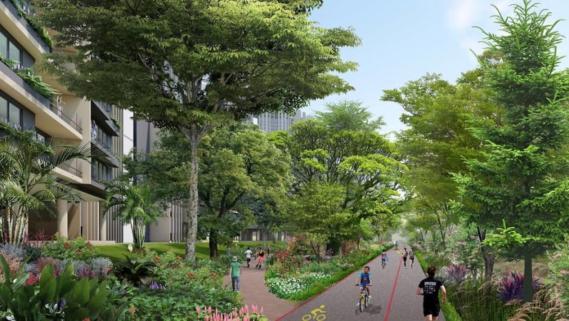
For starters, HDB is proposing a green corridor - measuring up to 40m wide at some stretches - along Ulu Pandan Canal to facilitate wildlife movement along Sungei Ulu Pandan.
The corridor could comprise “a linear park with a wider park connector, landscaped precinct green spaces within the public housing parcels, and the landscaped portion of the Ulu Pandan Canal”, said HDB.
Ulu Pandan Canal itself will be upgraded to strengthen flood protection in the area.
HDB added that “there are plans to introduce Active, Beautiful, Clean (ABC) Waters features at some stretches in tandem with the upgrading of the canal” – referring to an initiative to spruce up water bodies.
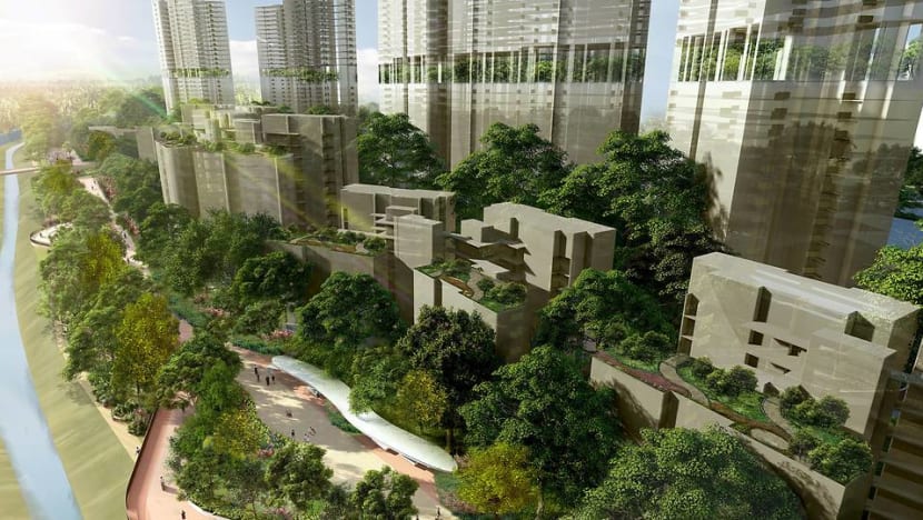
Housing blocks fronting the canal will also be stepped down and lower than the rest of the housing developments to maximise views to the canal, while greenery will be interwoven throughout the development.
Within the eastern side of Ulu Pandan, the Housing Board also hopes to retain an existing natural stream with 20m -wide buffers on both sides, because the stream has “valuable bank quality which offers an ideal habitat for aquatic biodiversity”, according to the environmental study.
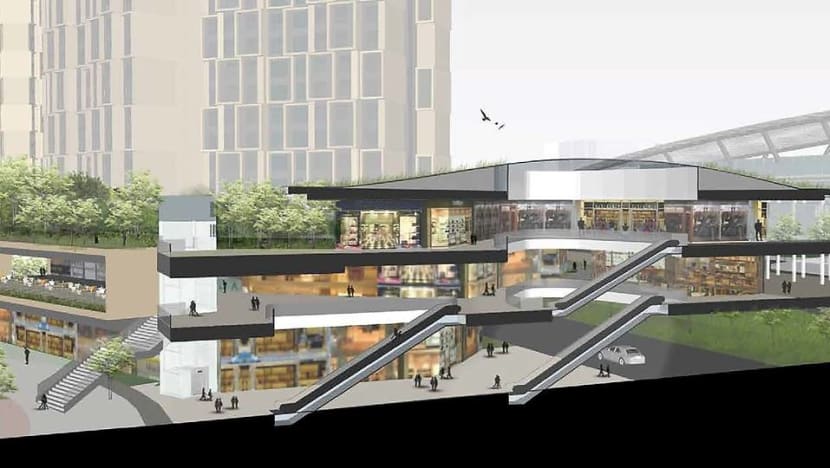
The precinct will be designed to be car-lite, said HDB, adding that a new commercial node will be developed next to the Dover MRT station to provide amenities for residents.
“We will also work with authorities to enhance the connectivity and barrier-free accessibility to Dover MRT station for residents’ convenience,” said HDB.
It added that in developing the site, a specialist consultant will be engaged to create plans to mitigate and manage any potential environmental impact arising from the infrastructure works, and closely monitor the works from start to end.
Speaking to reporters at a briefing, National Development Minister Desmond Lee said that authorities sought to strike a balance between various land-use needs - which has long been and will continue to be a challenge.
“I think with discipline, with an eye on the needs of the present … and remembering that as stewards we have a responsibility to the future too … and (applying) a scientific lens, we will be able to balance all these needs,” he said.
Dr Shawn Lum, president of the Nature Society (Singapore) said the planned development at Ulu Pandan has been designed “over many iterations” and “extensive consultations” with stakeholders.
“The development sets new standards for the integration of natural habitats and greenery into a housing development - both public and private – in Singapore,” he said.

