


Ringing in the new year at Marina Bay? Check crowd levels online first, police advise
The Crowd@MarinaBay map can be accessed from Dec 31, 6pm to Jan 1, 1.30am.

A photo of Marina Bay. (Photo: Urban Redevelopment Authority)


SINGAPORE: Revellers planning to join the new year countdown event at Marina Bay on Saturday (Dec 31) are advised to check crowd levels online before heading down to join the festivities, said the police.
An information portal, Crowd@MarinaBay, will go online at 6pm on Saturday. It will show real-time crowd levels and area closures, as well as features such as alternate walking paths.
Police officers, auxiliary police officers and security officers will be deployed to manage crowds at various locations such as The Promontory, One Fullerton/Merlion Park, Esplanade Park, Esplanade Waterfront Promenade and Marina Bay Sands Waterfront Promenade, the police said on Tuesday.
"When the capacity of these areas reaches planned safety thresholds, these areas will be closed to ensure the safety of members of the public," it said.
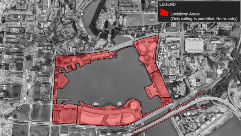
In the event of overcrowding, some entrances and exits of MRT stations around Marina Bay will be closed to regulate crowd flow. Trains may also skip affected stations such as Bayfront MRT station to divert the crowd away.
"MRT Stations including City Hall, Raffles Place and Bayfront MRT stations are expected to be very crowded. Members of the public are encouraged to use other nearby MRT stations such as Esplanade MRT station, Downtown MRT station and Marina Bay MRT station," said the police.
The police added that officers from the Special Operations Command, Protective Security Command, Public Transport Security Command, Police Coast Guard, Traffic Police, Emergency Response Teams and Aerial Response Team will also be deployed to enhance patrols during the countdown.
USE OF DRONES
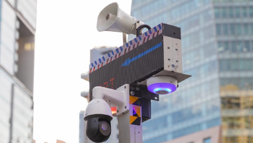
In addition to the Crowd@MarinaBay map, the police will deploy drones during the countdown to assist in crowd control.
The drones, equipped with thermal and visual sensors, will allow the police to check crowd size, flow and density. Some will also have speakers attached to broadcast public safety measures to the crowd.
Three types of drones - weighing 1kg, 5kg and 7kg - will be used. They will be only flown over water by specially trained officers, said Superintendent Sum Tuck Meng, the officer-in-charge of unmanned aerial vehicles in the police operations department.
.jpg?itok=DLBIenVK)
AFTER THE COUNTDOWN
Once the event is over, the police noted that crowd dispersal will likely be slow due to the large number of people.
To facilitate safe and orderly dispersal, there will be designated routes out of Marina Bay, including the area closures, with signs put up to guide the public.
Crowd flow into the MRT stations will also be regulated to prevent overcrowding.
"A huge turnout is expected at the Marina Bay area, and the police have carefully calibrated the crowd management plans for the event ... We seek the understanding of the public to be patient and to follow the instructions of police officers and marshals," said Superintendent Ho Li Fang.
ROAD CLOSURES
Road and lane closures will also be in place during the countdown.
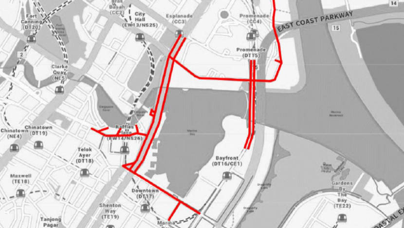
Affected roads and lanes
Dec 31, 6pm to 11pm
- Extreme left lane of Raffles Avenue (between Temasek Avenue and Esplanade Drive)
- Extreme left lane of Collyer Quay in the direction of Raffles Quay
Dec 31, 6pm to Jan 1, 2am
- Bayfront Avenue (between Temasek Avenue and lamp post 34F)
- Esplanade Drive in the direction of Fullerton Road (between Stamford Road and Collyer Quay)
- Fullerton Road (between lamp post 18F and Esplanade Drive)
Dec 31, 10pm to Jan 1, 2am
- Marina Boulevard (between Raffles Quay and Bayfront Avenue)
Dec 31, 11pm to Jan 1, 2am
- Republic Boulevard in the direction of Raffles Avenue (between Raffles Boulevard and Raffles Avenue)
- Slip road leading from Raffles Boulevard into Raffles Avenue
- Raffles Avenue (between Raffles Boulevard and Temasek Avenue)
- Temasek Avenue (between Raffles Boulevard and Raffles Avenue)
- Nicoll Highway (between Raffles Boulevard and Raffles Avenue)
- Esplanade Drive in the direction of Nicoll Highway (between Stamford Road and Collyer Quay)
- Fullerton Road (between Esplanade Drive and Collyer Quay)
- Collyer Quay (between Fullerton Road and Marina Boulevard)
- Battery Road
- Flint Street
- Bonham Street
- Fullerton Square
- Extreme left lane of Finlayson Green (between Collyer Quay and Marina Boulevard)
- Extreme left lane of Marina Way (between Marina Boulevard and Central Boulevard)


