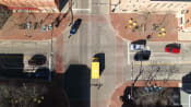
What does space technology have to do with Singapore’s ERP system and coastline?
As Singapore pushes forward with its Smart City initiatives, space-based technology will become increasingly vital.

FILE: The first made-in-Singapore commercial earth observation satellite was launched in December 2015.


SINGAPORE: The space industry is growing in Singapore, with technologies related to the sector increasingly playing a part in infrastructure development, businesses and everyday lives.
The Electronic Road Pricing (ERP) system, for instance, uses the Global Navigation Satellite Systems (GNSS) technology to improve traffic management and transport planning, and provide real-time alerts to motorists on traffic information and charging locations.
Web mapping services such as Google Maps and Apple Maps use satellite and aerial imagery to help users search and navigate locations.
The Government is exploring more ways to develop capacity in this area, with the Singapore Land Authority (SLA) leading in the use of geospatial information and technology to drive the Smart Nation and Future Economy initiatives.
“We are looking at some of the most important applications of space technology, which is in mapping and geospatial applications,” said Dr Victor Khoo, director of SLA’s Survey and Geomatics Division.
“(We use) the data to produce maps and geospatial (information) that would be beneficial to the daily lives of Singaporeans,” he told CNA938’s Asia First on Thursday (Feb 16).
The statutory board develops and manages the Singapore Satellite Positioning Reference Network (SiReNT), which supports real-time high precision positioning, navigation and tracking, and improves accuracy and reliability for global navigation.
“We are using it to give us very accurate coordinates. This network enhances the usage of GNSS or GPS to increase the accuracy from a few metres to a few centimetres,” said Dr Khoo.
CLIMATE CHANGE AND SMART CITY
“With this technology, we can do a lot of things. It is traditionally for mapping and surveying but going forward, we are using this in the area of sustainability – in monitoring sea level and vertical land motion. These are key for us to manage and to protect our coastline.”
Vertical land motion refers to the long-term rate of change of land surface, which is key to understanding how sea levels change and can impact Singapore’s coastline.
Using both space and ground technologies, SLA maps the island’s terrain and coastline and monitors changes, particularly in height, said Dr Khoo. It also uses the information to create terrain models of the country.
“Singapore is rather small. Space-based technology is a good source of data for us,” said Dr Khoo.
“We augment it with our ground-based data or airborne data such as airborne laser scanning and airborne imaging. We look at a combination or integration of all these data.”
As Singapore pushes forward with its Smart City initiatives, space technology is expected to become increasingly vital.
Related:
“Especially in the city, we are looking at security, safety, sustainability, as well as smart (technology). For example, we use GNSS or GPS to drive an autonomous vehicle. Without this technology it is very hard to get a robot to move autonomously.”
SPACE TECH IN SINGAPORE
Dr Khoo spoke about the role of space in the rise of geospatial applications at the Global Space and Technology Convention (GSTC), held on Wednesday and Thursday in Singapore.
The event brought together more than 800 thought leaders, industry players and investors from more than 40 countries to discuss wide-ranging topics including frontier technology development, global collaboration of space agencies, and space and sustainability agendas.
Ms Lynette Tan, CEO of Singapore Space and Technology, said the convention aimed to facilitate deal flows among countries, businesses and professionals in the “galactic” industry to better understand technological developments, share resources and work towards a common ambition.
“Space is now a cornerstone in the Singapore ecosystem. It is ubiquitous in our everyday life and in our innovation development,” she told CNA938.
“Space is the first place for inspiration … a public incubator where inventions take place. Future jobs in this sector are going to be very demanding, especially in the sophistication of the skills required.”
To attract more talent into the industry, a new Space Internship Programme was launched during the convention with at least 95 openings across space tech companies from now till 2026.
“We are creating opportunities to encourage students to learn about STEM (science, technology, engineering and mathematics) and to be inspired through the space environment,” said Ms Tan.
Transport Minister S Iswaran said during the convention that there has been significant growth in new technologies, businesses and investments in the space sector in recent years.
The global space industry is valued at more than US$400 billion today, and is set to more than double to US$1 trillion by 2030.
More than 60 local and international space companies are based in Singapore, employing about 2,000 professionals and researchers.