CNA Explains: Early signs of El Nino's return – what can we expect?
Singapore experienced one of its hottest years on record and about 35 per cent below average rainfall during the last strong El Nino event in 2015 and 2016.

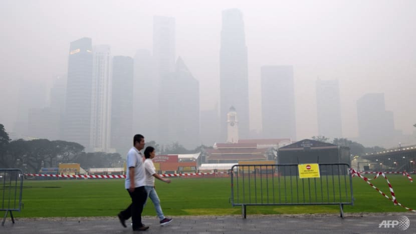
The Singapore skyline is seen shrouded in haze on Sep 14, 2015. (File photo: AFP/Roslan Rahman)
SINGAPORE: The Meteorological Service Singapore on Tuesday (May 30) forecast that El Nino conditions will develop in the second half of 2023.
This follows three years of La Nina conditions and comes seven years after the last strong El Nino event. The Met Service also predicted that a positive Indian Ocean Dipole (IOD) event will develop during the same period.
"There is a 70 per cent to 80 per cent chance of an El Nino event occurring this year," the Met Service said in an advisory.
"There are already signs since earlier this year that support El Nino conditions developing in the next few months.
"These include the warmer subsurface ocean temperatures observed in the eastern tropical Pacific, typically a precursor to El Nino events."
So what exactly are El Nino, La Nina and the IOD? And how do these climate phenomena affect Singapore and the surrounding region?
CNA takes a closer look.
What are El Nino and La Nina?
El Nino and La Nina are climate patterns in the Pacific Ocean that can affect weather worldwide.
Both phenomena are caused by, and contribute to, naturally occurring climate variability, according to the World Meteorological Organization (WMO).
"They disrupt the normal patterns of tropical precipitation and atmospheric circulation and are considered to be the opposite phases of air-sea interactions collectively referred to as the El Nino-Southern Oscillation (ENSO)," WMO said on its website.
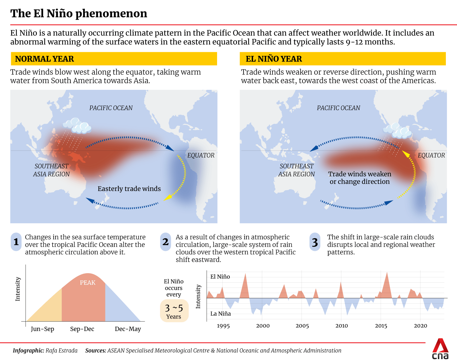
El Nino and La Nina "occur every two to seven years and typically last for nine to 12 months, and have widespread impacts on weather around the world".
The Spanish term El Nino was first used by fishermen along the coasts of Ecuador and Peru to refer to a warm ocean current that typically appears around December and lasts for several months, the United Kingdom's Royal Meteorological Society said on its website.
El Nino can be translated as "little boy", and La Nina, on the other hand, means "little girl".
In the absence of El Nino or La Nina, the ENSO is in a neutral state. This is the state that Singapore and the region are currently experiencing as of May and June 2023, according to the National Environment Agency (NEA).
What causes the different ENSO states?
"During normal conditions in the Pacific Ocean, trade winds blow west along the equator, taking warm water from South America towards Asia," the National Ocean Service (NOS) of the United States National Oceanic and Atmospheric Administration said on its website.
"To replace that warm water, cold water rises from the depths – a process called upwelling.
"El Nino and La Nina are two opposing climate patterns that break these normal conditions."
During an El Nino event, trade winds weaken, and warm water is pushed back east towards the west coast of the Americas, NOS said.
When a La Nina event occurs, the opposite is true: Stronger trade winds push more warm water toward Asia.
During a neutral state, there is more rain in the western tropical Pacific compared to the east, according to NEA.
During an El Nino event, the central and eastern tropical Pacific receive more rain while the western tropical Pacific sees less.
Correspondingly, the central and eastern tropical Pacific receive less rain while the western tropical Pacific receives more during a La Nina event.

What is the Indian Ocean Dipole?
The IOD is similar to ENSO, but events occur in the equatorial Indian Ocean and have a shorter duration.
The IOD varies between three phases – positive, negative and neutral.
A positive IOD event, which suppresses cloud formation over certain parts of the tropical Indian Ocean, typically brings drier and warmer conditions to many parts of southern Southeast Asia.
When is an El Nino event declared?
Singapore monitors ENSO conditions using the Nino3.4 index, which averages sea surface temperature anomalies in the central-eastern equatorial Pacific Ocean.
According to the Met Service, the threshold for an El Nino event in the Nino3.4 region is a figure of more than 0.65 degrees Celsius above normal according to the index. The threshold for a La Nina event is a figure of more than 0.65 degrees Celsius below normal.
What is the impact of El Nino on the weather in Singapore?
During an El Nino event, Singapore can expect its rainfall to be affected significantly.
"El Nino events tend to have the biggest influence on Singapore's rainfall during the southwest monsoon season from June to September, with rainfall up to 45 per cent below average," the Met Service said.
"During the last strong El Nino event in 2015/2016, Singapore's total rainfall from June to September 2015 was about 35 per cent below the long-term average."
Temperatures will also rise during such an event.
"El Nino events also bring warmer temperatures to Singapore, with the warmest temperatures often occurring when El Nino events weaken typically in March to April the year following the start of the event," the Met Service said.
"During the 2015/2016 El Nino event, Singapore's average temperature over the June to September 2015 period was 28.8 degrees Celsius or 0.6 degree Celsius above its long-term average for that period.
"For the period from March to April 2016, Singapore's average temperature was 29.2 degrees Celsius or 1.2 degrees Celsius above its long-term average for that period."
The Met Service added that 2016 was one of Singapore's hottest years on record, along with 2019.
Should Singapore expect transboundary haze?
The southwest monsoon period between June and September is typically the dry season for Singapore and the surrounding region.
An El Nino event and a positive IOD event could raise the intensity of this dry season and extend it into October, increasing the risk that haze will impact Singapore.
"Drier and warmer conditions are conducive to the development of peatland and vegetation fires," the Met Service said.
"Therefore, hotspots could escalate from June 2023 under extended periods of drier weather, particularly in fire-prone areas.
"This will increase the risk of transboundary haze affecting Singapore if fires develop in close proximity and prevailing south-easterly to south-westerly winds blow smoke haze from the fires towards Singapore."
On Monday, the meteorological centre of the Association of Southeast Asian Nations (ASEAN) also flagged a higher risk of escalated hotspot activity and transboundary haze in the southern ASEAN region from June to October.
The ASEAN Specialised Meteorological Centre (ASMC) made this announcement as it issued Alert Level 1, indicating the start of the dry season associated with the Southwest Monsoon in the southern ASEAN region.
Hotspot activity in the southern ASEAN region is presently still subdued, however, with 14 and 13 hotspots detected in the southern ASEAN region on May 27 and May 28 respectively, ASMC said.
A few localised smoke plumes were detected in parts of the region on some days in May, but no transboundary smoke haze occurrence has been observed so far.
NEA has convened the Inter-Agency Haze Task Force to review and prepare Singapore's responses in case of transboundary haze, Minister for Sustainability and the Environment Grace Fu said in a Facebook post on Tuesday.
"As a precaution, Singaporeans may wish to make preparations to protect your loved ones, such as by ensuring that you have an adequate supply of N95 face masks and your air purifiers are in good working condition."
Is climate change affecting El Nino?
According to the Royal Meteorological Society, it is unclear what effect climate change is having on ENSO.
"Because of the large event-to-event variations of El Nino, we don't have enough past years of observations to show a clear impact of climate change on its properties," the society said on its website.
"However, there is now some evidence that the effects of El Nino on rainfall may increase in the future and that we may even see more extreme ENSO events, but these remain active research questions."


