Commentary: India’s new map ruffles regional feathers
Redrawing national boundaries has provoked concern in Pakistan, Nepal and Bangladesh, says the Financial Times’ John Reed.

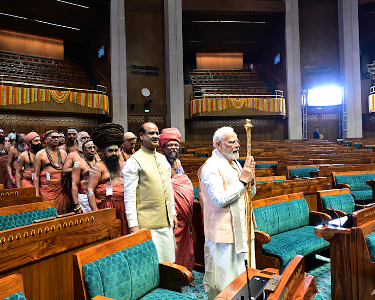
A three-dimensional map on a mural inside India's new parliament building has caused a fresh stir. (Photo: Twitter/@JoshiPralhad)
NEW DELHI: India’s new triangular parliament building - set alongside the old circular, colonnaded structure of British colonial rule - symbolises its efforts to build a country free from the trappings of past foreign domination.
But its inauguration has not been straightforward. Indian Prime Minister Narendra Modi carried a gold sceptre as he presided over the opening last month in the company of Hindu holy men.
This gave fuel to his opponents, who repeated longstanding claims that he was fraying India’s secular constitutional democracy and argued that President Droupadi Murmu, the head of state, should have been allowed to open the building. Opposition parties boycotted the ceremony and the Indian National Congress’s Rahul Gandhi, Modi’s chief nemesis, dismissed it as a “coronation”.
A FRESH STIR
Even after that controversy died down, a three-dimensional map on a mural inside the new building has caused a fresh stir.
The mural features a backlit outline of the subcontinent without any of its present-day borders, stretching west to Pakistan and Afghanistan and east as far as Myanmar. The names are archaic and some of the cities labelled are in other countries, including Purushpur, the Sanskrit name for Peshawar, Pakistan.
Officials and opposition politicians in Pakistan, Nepal and most recently Bangladesh have voiced concerns.
India’s foreign ministry insists that the mural depicts the spread of the third century BC empire ruled by Ashoka the Great, “and the idea of responsible and people-oriented governance that [he] adopted and propagated”.
But some members of Modi’s Bharatiya Janata Party (BJP) had claimed the map represented “Akhand Bharat” (“undivided India”), a maximalist conception of a greater India floated by some Hindu nationalists that incorporates swaths of neighbouring countries.
Pralhad Joshi, a government minister, asserted: “The resolve is clear - Akhand Bharat” in a tweet with the hashtag #MyParliamentMyPride on the day of the opening. Manoj Kotak, a BJP member of parliament representing Mumbai, also tweeted about “Akhand Bharat in new parliament”, adding: “It represents our powerful and self-reliant India”.
PAKISTANI FOREIGN MINISTRY “APPALLED”
Pakistan’s foreign ministry declared it was “appalled” by the statements made by some BJP politicians, and said it was “a manifestation of a revisionist and expansionist mindset that seeks to subjugate the identity and culture of not only India’s neighbouring countries but also its own religious minorities”.
Some of the outrage - not least from India’s arch-enemy Pakistan - may reflect broader tensions, or have been manufactured for domestic political purposes. And India is not the only country where maps have caused problems with the neighbours.
Hungarian leader Viktor Orban last year riled Romania and Ukraine when he was seen wearing a football scarf featuring the outlines of a “Greater Hungary” in the country’s pre-1920 borders. Chinese maps featuring the Nine Dash Line, its unrecognised claim on most of the South China Sea, routinely cause fury in neighbouring countries such as Vietnam.
MAP GOES AGAINST THE EXPECTATIONS OF A “REGIONAL LEADER”
However, India’s map is literally embedded in stone in a building Modi called a “temple of democracy”, in a country that styles itself as a regional leader.
“As the largest nation and economy, India ought to reach out in a positive way to its neighbours,” says Aakar Patel, an author and government critic. “The map is going in the opposite direction than we should be going”.
None of the map’s critics is claiming that India has active annexation plans. Some point out too that an imaginary “Greater India” incorporating Pakistan and Bangladesh would be home to a huge non-Hindu population, running at cross purposes with the BJP’s project to create a Hindu rashtra (nation).
What’s telling is the speed with which objections have started to ebb away in a region where India is the biggest economy and a growing foreign investor.
Governing officials in Nepal and Bangladesh - which have good relations with the Modi administration - initially protested but are now happy to accept the explanation that the map was a historical one.
Indians will have the chance to judge for themselves when the building opens to the public next month.