PUB to add 650 sensors, working to put alerts on Google Maps to bolster Singapore's flood readiness
The planned feature on Google Maps aims to give motorists and commuters access to flood information to better plan their routes on rainy days.

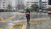
PUB’s quick response team was deployed to direct traffic away from flooded lanes and provide assistance to motorists on Apr 20, 2025. (Photo: Facebook/PUB)

This audio is generated by an AI tool.


SINGAPORE: About 650 water level sensors will be installed across Singapore by end-2028, adding to the more than 1,000 sensors already in drains and canals to strengthen the country’s flood management capabilities, PUB said on Monday (Nov 17).
Singapore's national water agency is also working with Google to integrate flood alerts on its Google Maps platform, with the planned feature giving motorists and commuters access to flood information to better plan their routes on rainy days. Flood alerts are already available on Grab’s mobile app and the Land Transport Authority’s Electronic Road Pricing (ERP) on-board units.
These upcoming measures were announced as PUB launched its second flood resilience campaign on Monday ahead of the Northeast monsoon season, which is expected to start end-November and last until March 2026.
“Through enhanced monitoring, real-time alerts, and community engagement, PUB is strengthening Singapore's flood resilience," the agency said.
Deputy Chief Executive of PUB’s flood resilience cluster Angela Koh added that flood monitoring and response is a key part of the agency’s efforts to mitigate the impact of flooding.
In addition to data from water level sensors, PUB draws on information from more than 500 closed-circuit television cameras, rain gauges, weather radars and flood response vehicles to enhance its rainfall forecasting and flood response capabilities.
The expanded network of water level sensors will provide monitoring coverage of about one sensor per kilometre of major waterways and canals, allowing faster detection of rising water levels and quicker deployment of quick response teams.
"These sensors also support post-flood investigations and help us better assess the effectiveness of our drainage infrastructure," said Ms Koh.
They will feed data into the Smart Drainage Grid, which analyses sensor and rainfall data from rain gauges to help PUB identify flood causes and recommend improvement measures.
PUB also gave an update on efforts to mitigate the impact of flooding in Bukit Timah and Yishun.
Works are underway to widen and deepen a 900m stretch of the main Bukit Timah Canal - from Rifle Range Road to Jalan Kampong Chantek - to increase its capacity for rainwater by 30 per cent.
This was supposed to be completed in 2024, but has been delayed until 2026 to sync with the development of a green corridor.
PUB said on Monday there are plans to progressively upgrade the remaining downstream stretches, as well as expand the roadside drains along Prince’s Road, King’s Road and Queen’s Road.
Flood mitigation measures have also been implemented after a flash flood occurred along Yishun Avenue 7 in April.
PUB said the flooding was caused by an undersized culvert along Yishun Avenue 7 and a downstream roadside drain leading to Yishun Street 22, which created a bottleneck that caused water to back up and flood the road.
Weirs, which are barriers altering water speed and flow, have since been installed at the upstream drains along Yishun Street 22 and Yishun Avenue 7.
Railings along Yishun Avenue 7 have been modified into flood barriers, while a one-way valve has also been installed, with PUB currently monitoring their effectiveness.