


Parts of Sungei Buloh could flood by design under coastal protection plans for northwest Singapore
Participants of a focus group discussion also discussed the possibility of using the dam at Kranji reservoir and the tidal gatehouse as recreational and educational spaces.

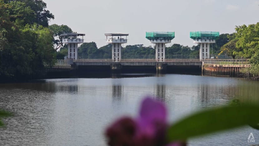
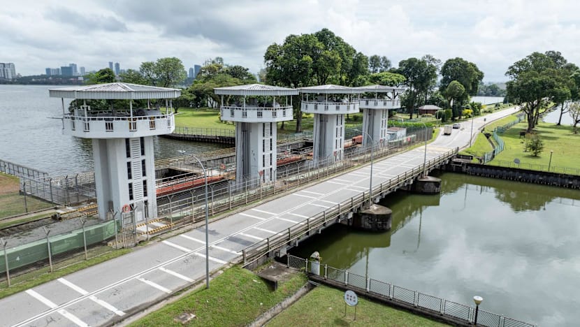
Sungei Buloh Wetland Reserve. (Photo:CNA/Koh Wan Ting)

This audio is generated by an AI tool.


SINGAPORE: As torrential rain lashes the northwest coast of Singapore, home to the country's first wetland nature reserve at Sungei Buloh, a public alarm system blares a warning to get people to evacuate areas prone to flooding.
Then, as water levels rise to around 80cm, certain areas of the nature reserve – like its car park – become submerged temporarily for several hours, until the rain stops and the water finally recedes to the coast.
This is what the future could look like in Singapore's northwest coast, where authorities are considering designating the public trails around the Sungei Buloh Wetland Reserve visitor centre and the nearby carpark as a "transiently floodable coastal area" – allowing it to flood during extreme high tides or storm surges.
Besides the car park, the existing dam at Kranji reservoir could be converted into a "multi-functional" infrastructure, and the Kranji tidal gatehouse could be repurposed into an educational destination.
The dam structure could also be widened and raised as part of potential coastal protection measures.
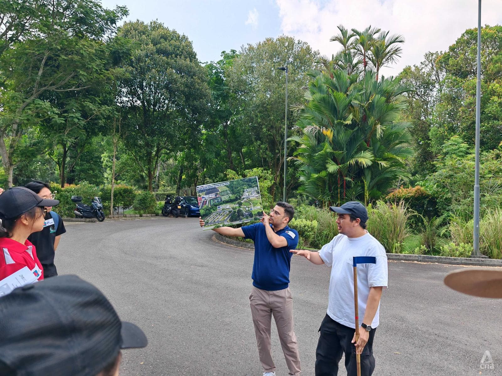
These were among several key suggestions presented to 50 participants at a community dialogue on measures to protect a part of Singapore's northwest coast held at Sungei Buloh Wetland Reserve's visitor centre on Saturday (Sep 27).
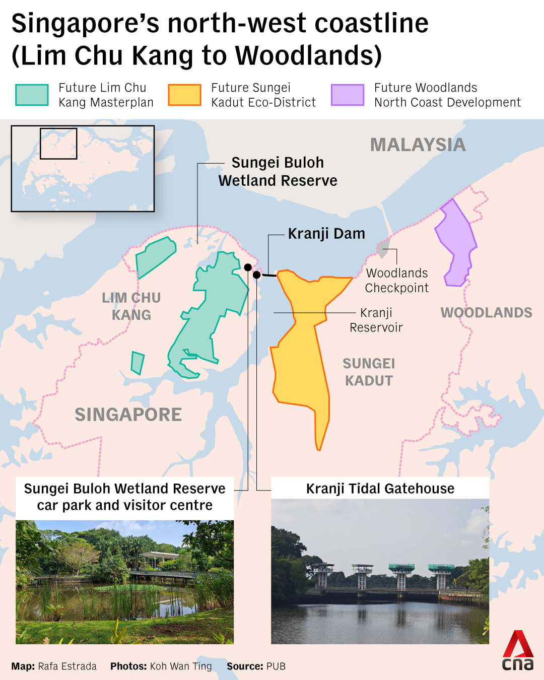
The section of the northwest coast under discussion stretches from Lim Chu Kang to Woodlands, and is currently undergoing a site-specific study which commenced in 2023 as a response to sea level rise. Another stretch of the northwest coast, from Tuas to Lim Chu Kang, is the subject of another study that started in April 2022.
The dialogue is part of the Our Coastal Conversation series, organised by national water agency PUB to engage the public on the long-term challenge of rising sea levels around the country.
Senior Parliamentary Secretary for Sustainability and the Environment Goh Hanyan, who was at the session, cited several examples of how coastlines in other parts of Singapore can be reimagined.
At the Marina Barrage for example, coastal protection measures are integrated with new spaces for living and recreation, while the future long island at Singapore's east coast could make use of land reclamation to make the coastline more usable and liveable.
At the same time, implementing such measures could result in "trade-offs" in other areas, she noted.
"Some options may require sacrificing productive land, meaning less space for housing or industry. Others might necessitate rethinking parts of our natural environment and biodiversity," Ms Goh said.
"Sometimes, it may also mean allowing certain areas of Singapore to flood briefly during specific periods, then return to normal function afterwards, so that we do not need to undertake major construction works in those areas," she added.
Singapore's third National Climate Change Study projects that the mean sea level could rise up to 1.15m by the end of the century.
Extreme weather events, such as high tides and storm surges, could cause levels to spike by 4m to 5m, putting low-lying areas at risk.
As part of efforts to ramp up coastal protection, PUB has been progressively studying segments of the coastline since 2021.
CHARACTERISTICS OF THE NORTHWEST COAST
The northwest section of Singapore's coastline under study is a 15km stretch that encompasses Sungei Kadut, Woodlands and Lim Chu Kang. This includes the future high-tech agri-food zone that is key to Singapore's food security goals.
Other landmarks in the area include the future Sungei Kadut Eco-District, Woodlands Checkpoint, Kranji Reservoir and Sungei Buloh Wetland Reserve.
It is also home to several nature parks such as Kranji Coastal Nature Park, Lim Chu Kang Nature Park, and the upcoming Mandai Mangrove and Mudflat Nature Park.
Swathes of the Kranji area as well as Sungei Buloh Wetland Reserve currently lie less than 5m above mean sea level, which means that the area is vulnerable to rising seas.
Senior deputy director of coastal engineering Thoo Jung Chee, from PUB's Coastal Protection Department, said that studies for the northwest coast are making "steady progress" and are expected to complete in one to two years.
"This stretch of the coastline has varied land use, rich biodiversity areas and also key upcoming developments. As part of the areas also include opportunities to integrate multi-functionality ... hence, it is important that we seek the views and feedback from our community and stakeholders and on the potential measures and the trade-offs," Mr Thoo said.
"To ensure a sustainable and liveable coastline, some key considerations in the studies include integrating measures with the existing and future land use, and also designing with nature in mind. For example, we can locate our measures behind the mangrove habitats, and also (allow) parts of the Sungei Buloh Wetland Reserve to be transiently floodable during extreme sea levels," he added, pointing to the car park as an example.
Related:


Asked about the challenges of this segment of the coast, consultancy firm Arup, the lead for the site- specific study, said that this part of the coast presented a diverse landscape with varied use.
"Nature areas such as Sungei Buloh Wetland Reserve and the Mandai Mangrove and Mudflat (Nature Park) are sensitive environments that need to be managed with care, but we see how they can provide unique potential for nature-based solutions that safeguard developments while enhancing biodiversity," Arup spokesperson Peter Stones said.
Given its current nature, future measures must balance protecting developments with preserving the northwest coast’s sensitive ecosystems, Mr Stones said.
For example, the mangroves and mudflats depend on sea connectivity, so hard coastal barriers may be unsuitable.
"Instead, strategies could leverage existing mangroves as natural defences while enhancing ecological resilience," he said.
Meanwhile, urbanised industrial districts, like the upcoming Sungei Kadut Eco-District, present opportunities to innovate in space efficiency and safety.
"Ongoing redevelopment plans across the northwest coast present further opportunities to align coastal protection works with district transformation, ensuring long-term resilience and future-ready growth."
However, Mr Stones noted that each measure comes with its own benefits and trade-offs.
For instance, a vertical flood wall could take up very little space and provide strong protection, but it can hinder plants and wildlife from moving naturally between land and sea.
"On the other hand, a sloped, planted embankment requires more space but allows biodiversity to flourish and creates a greener, more welcoming edge to the coast," he added.
Arup uses tools and processes to weigh options against a broad set of factors: cost effectiveness, environmental sustainability, social and community impacts, and flood protection effectiveness.
"By taking this balanced approach, we aim to recommend coastal protection strategies that protect against floods but also enhance the character, ecology, and liveability of the northwest coast," Mr Stones added.
WHAT OPTIONS ARE AVAILABLE
A total of 50 participants, which included university students, engineers, business owners, cycling and fishing hobbyists and nature enthusiasts, attended the session on Saturday morning.
They were taken in groups on a short tour around Sungei Buloh Wetland Reserve to better understand the site's conditions, before reconvening into groups to discuss and present their ideas.
On the idea of transiently flooded areas, some participants gave feedback that the phenomenon is similar to flooded forests and can be turned into a unique experience and become a "character of the area", though there were also concerns about ensuring visitors' safety.
To that end, participants suggested an alert system similar to what is implemented by Ang Mo Kio–Bishan Park, where warning lights, sirens and safety announcements inform visitors to move away from the river banks which could get flooded during heavy rain.
Focus group participant Isaac Ong, who is also the programmes head of Singapore Youth Voices for Biodiversity, said a transiently flooding car park could be used for public education.
"We could bring students here and ... they can have a firsthand example of ... learning what sea level rise and coastal protection is like, and flooding is a very natural occurrence.
"So I don't think that there should be necessarily an over-engineering of solutions. And I think working with nature instead of working against it is ideal," said the 21-year-old first-year life sciences student at the National University of Singapore.
An alternative option presented to participants is an "earth bund" – a barrier constructed from soil, a tidal gate and a pumping station – to prevent the areas around the visitor centre and car park from flooding.
The four tidal gate towers and dam which separate Kranji reservoir from the sea were also discussed. The Kranji reservoir dam, which was built in 1975 across the mouth of Sungei Kranji, prevents seawater from entering the freshwater reservoir.
The 475m-long dam currently has a road for vehicle use but lacks cycling paths or shelter. The tidal gate towers, located at one end of the dam, is similarly bare of amenities.
On this point, participants discussed opportunities to incorporate features such as footpaths or cycling paths to improve connectivity in the vicinity. The tidal gatehouse could also be repurposed as viewing decks, waterfront cafes or educational spaces, suggested some participants.
Speaking to reporters after the dialogue session, Mr Francis Chu, the co-founder of cycling group Love Cycling SG, said he would like to see the area have better cycling access as part of its coastal protection measures.
"I tried this morning, cycling from Kranji MRT to Sungei Buloh ... and some parts of the route are quite dangerous especially along the dam. There's no walking path, there's no cycling path, and if you cycle on the road you have to mix with heavy vehicles," the 65-year-old said.

Reflecting on feedback, Ms Goh noted in one of her takeaways of the session that everybody had a different risk tolerance. On the transient flooding feature for example, people had varying acceptance levels depending on the frequency and duration of each flood occurrence.
"And everyone has a different level, and that's something that we then have to engage everyone ... to understand what the risk tolerance (is)."
"Because at the end of the day, 10, 100 years from now, flooding is going to be something you have to grapple with anyway, right? So it's best that we understand it, we prepare ourselves for it ... and it's not a bad thing, because it's natural, it's going to happen. So let's make the best out of it."


