Indonesia identifies location of two Singaporean hikers at Mount Dukono but eruptions hamper rescue
Indonesia’s disaster mitigation agency says the hikers’ locations were identified on Friday (May 8), but rescue efforts have been hampered by extreme terrain and heightened volcanic activity.

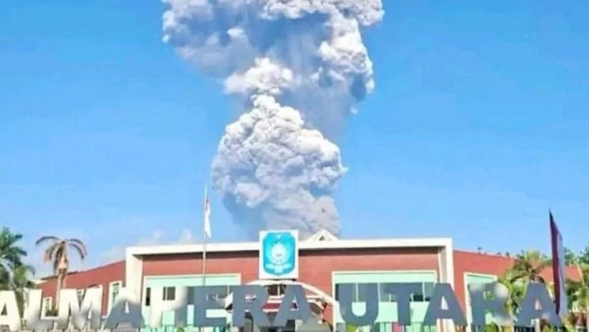
A handout picture taken and released on May 8, 2026, by Indonesia's National Search and Rescue Agency (BASARNAS) shows rescue workers standing by after the volcanic eruption of Mount Dukono in North Halmahera, North Maluku. (Photo: Handout/BASARNAS/AFP)
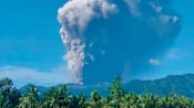
JAKARTA: Indonesian authorities resumed their search on Saturday (May 9) for three hikers missing after Mount Dukono erupted on the Pacific island of Halmahera.
At least 100 rescuers, military and police personnel, as well as two thermal drones, have been deployed to find the two Singaporeans and one Indonesian, Iwan Ramdani, the head of the local rescue agency, told Reuters.
Survivors have told police that three people, including two Singaporeans, died in Friday's eruption, local police chief Erlichson Pasaribu said, but the rescue agency had not confirmed the deaths by Saturday.
On Friday, the local search and rescue agency identified the two missing Singaporean hikers as Heng Wen Qiang Timothy, 30, and Shahin Muhrez bin Abdul Hamid, 27, as it published a list of the survivors and missing.
Mount Dukono in North Maluku province erupted on Friday morning, spewing ash as high as 10km into the sky.
"We are focusing the search around the crater, covering an area around 700 metres," Iwan said. Authorities on Friday evacuated 17 people - seven Singaporeans and 10 Indonesians.
The rescue agency had halted the search on Friday evening as the volcano continued to erupt. Saturday's search remained hampered, Iwan said, as the volcanology agency reported at least four morning eruptions.
Indonesia’s disaster mitigation agency BNPB said on Saturday that the locations of two foreign nationals were identified during Friday's search operation, but rescue efforts could not proceed because of extreme terrain conditions and heightened volcanic activity around Mount Dukono.
Preliminary information indicated that they were located about 20m to 30m from the volcano’s main crater, BNPB said in a Facebook post, adding that any evacuation would require careful planning due to the risk of escalating volcanic activity and safety concerns for rescue personnel.
The Indonesian climber has yet to be located, with search efforts continuing, BNPB said.
Rescuers face tough conditions on the ground as they contend with a constantly erupting volcano.
"The danger here is not about when it will erupt, but how large the ejected material is," Eko Teguh Paripurno, a volcanologist from Universitas Pembangunan Nasional "Veteran" Yogyakarta, told CNA, adding that conditions at the summit can change rapidly - especially if the wind direction shifts suddenly.
Eko described the presence of unofficial routes as the biggest challenge for authorities, saying they "effectively paralyse the monitoring system".
A receptionist at a hotel in Tobelo, the closest town to Mount Dukono, told CNA on Friday that there are two access routes to the volcano - an official hiking trail and an unmonitored alternative route that was frequently used by tourists despite the eruptions.
A local tour guide, citing fellow guides, said that the victims had taken a faster but more dangerous route up Mount Dukono, although it remains unclear whether the path was unofficial.
"Authorities have no data on who is on the mountain, how many people are there, and where hikers are located when the danger escalates," Eko said, referring to hikers using unofficial routes.
Such a situation also directly affects search and rescue operations, making them more difficult, costly and risky, he added.
Singapore's Ministry of Foreign Affairs and embassy in Jakarta were working with the Indonesian authorities to gather information and provide consular assistance and support to the affected Singaporeans and their families, the ministry said in a statement on Friday.
The volcanology agency is maintaining the third-highest alert level for Mount Dukono, said Lana Saria, the agency's head, adding that residents and tourists were advised not to do any activities within 4km of the crater.
There were no reports of flight disruptions caused by the eruption.
Indonesia sits on the Pacific "Ring of Fire", an area of high seismic activity atop various tectonic plates.