


commentary Commentary
Commentary: Why that unusually high rainfall in Singapore during the last summer monsoon may be our new normal
The June to September season this year was the wettest season in terms of most rainy days at the Changi climate station since 1982, highlighting the effects of climate change, say Dhrubajyoti Samanta and Benjamin P Horton.

A person with an umbrella in the rain in Singapore. (File photo: Jeremy Long)


SINGAPORE: This year’s June to September was wetter than normal. This is partly due to the intense moisture-laden winds blowing from the tropical Indian Ocean and Java Sea toward Southeast Asia.
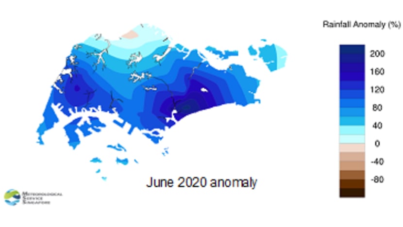
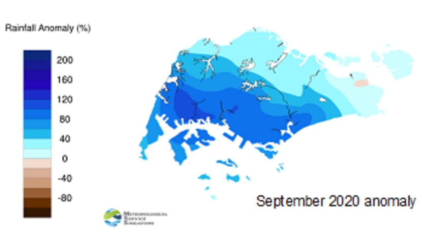
As per the Meteorological Service Singapore (MSS) report, June was the wettest, and September the second wettest in the last 10 years.
During this entire season, higher rainfall was observed in the western part of Singapore.
Apart from an increase in mean seasonal rainfall, Singapore also experienced more rainy days during this period.
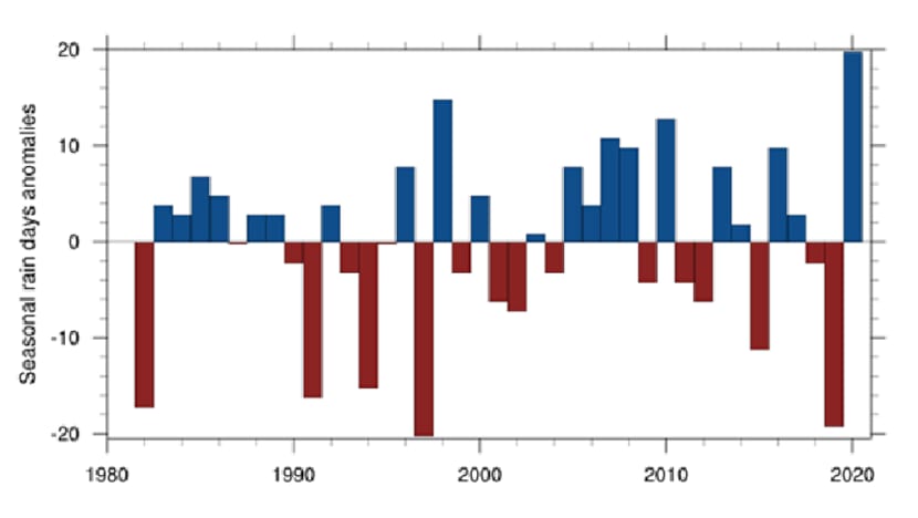
Changi climate station experienced a total of 73 rainy days in the season compared to the long-term average of 53 days over the past three decades, making it the wettest season in terms of most rainy days at the Changi climate station since 1982.
During this season there were several events with extremely heavy rain, such as on Jun 23, Aug 23, and Sep 12.
Despite its extensive drainage system, several flash flood events still occurred, such as the filling up of the Bukit Timah canal on Sep 12.
SOUTHWEST MONSOON PATTERNS TRADITIONALLY CONTRIBUTE TO RAIN IN JUNE TO SEPTEMBER
While the June to September anomaly is curious, it’s worth reminding ourselves that Singapore does see its share of heavy rains. Being a tropical country, Singapore experiences rainfall throughout the year.
Rainfall affects all residents in Singapore which has a huge impact on our daily activities and travel. Singapore’s rainfall is largely influenced by the northeast (winter) and southwest (summer) monsoon.
While winter monsoon (December to March) causes the highest rainfall of the year, southwest monsoon (June to September) has also an important role in Singapore’s weather.
The weather and rainfall in Southeast Asia during June to September are largely controlled by patterns of wind-flow associated with the southwest monsoon system.
In Singapore, low-level wind generally blows from south or southeast during June to September. The combination of moisture-laden wind from warmer ocean and monsoon rainband near the equator causes moderate to heavy rainfall during late morning and afternoon.
LISTEN: How hot can cities get and what can we do to cool things down?
READ: Commentary: The world is hungry for green cooling solutions. Thankfully, Singapore is pioneering them
ROLE OF SUMATRA SQUALL
But the question remains why this uptick in rain happens and how concerned we should be.
In addition to the southwest monsoon, rainfall in Singapore during June to September depends on the number of Sumatra Squall events.
Sumatra Squall is an organised thunderstorm line that usually develops over Sumatra island or the Straits of Malacca overnight, which then moves eastward to affect Singapore and peninsular Malaysia.
Typically, the Sumatra Squall can bring about one to two hours of predawn or morning showers with thunder.
Interestingly, this year, Singapore has experienced higher number of Sumatra Squall events that has a significant role on the higher amount of rainfall in Singapore and several flash flood events.
LA NINA CONDITIONS IN THE TROPICAL PACIFIC OCEAN
Singapore’s seasonal rainfall varies year-to-year, and is also largely controlled by El Nino Southern Oscillation (ENSO).
ENSO has three phases, El Niño, La Niña, and neutral phase. During a La Niña episode, the cooler than normal sea surface temperature over the eastern tropical Pacific Ocean is accompanied by an increase of east-west sea level pressure gradient that drives the trade winds.
The reverse happens for Niño episodes.
Such a La Niña condition, like the one Singapore is experiencing these past few days, helps to develop frequent and intense deep convection and rainfall over the maritime continent.
The developing La Niña conditions likely had a role in increased rainfall during the latter part of the season (June to September) in 2020.
However, higher seasonal rainfall during the early season of 2020 (in June) was unlikely to be due to La Niña, since La Niña was not properly developed by that time.
READ: Commentary: How prepared is Singapore for the next flash flood?
LISTEN: Getting down to the big picture science of climate change
CLIMATE CHANGE
Like each part of the world, Singapore is also experiencing the impact of climate change. Wetter conditions in Singapore in recent decades is one of the key indications of climate change over this region.
The annual rainfall total for Singapore since 1980 has increased at an average of 67 mm per decade (up to 2019), whereas, the annual number of very heavy rainfall days (hourly rainfall exceeding 70 mm) has increased by 0.2 days per decade.
Despite the occasional flash floods during heavy rainfall, Singapore’s infrastructure is more than capable of draining out most of these rainfalls.
However, the rising sea level in this region can pose further challenges in the coming decades, if the rainfall increase trend continues. Are we prepared for a wetter Singapore in the future?
Dr Dhrubajyoti Samanta is a Senior Research Fellow at The Asian School of the Environment at Nanyang Technological University (NTU). Professor Benjamin P. Horton is the Director of NTU’s Earth Observatory of Singapore.


