analysis Asia
Unusual alignment of two climate forces behind record-breaking rain, floods in Southeast Asia
Southeast Asia is enduring one of its wettest seasons in recent memory, with record floods, consecutive typhoons and widespread displacement testing the region's capacity to adapt.

Flooding submerges houses in Hoi An ancient town, Vietnam, on Oct 30, 2025. (Photo: Phan Anh Dung/VNA via AP)

This audio is generated by an AI tool.


BANGKOK: Southern Thailand engulfed by rising waters. Entire towns cut off by record floods in Vietnam. The Philippines picking up the pieces from consecutive typhoons. Malaysia bracing for a long and heavy wet season.
Over just a few weeks, much of Southeast Asia has been drenched by one of its most punishing wet seasons in recent memory, a chain of floods and storms stretching from the Gulf of Thailand to the Pacific.
Millions of people have been displaced and hundreds killed by compounding extremes, and experts told CNA this is the outcome of a convergence of weather systems and the amplifying effect of climate change.
Two major climate systems - La Niña and a negative Indian Ocean Dipole characterised by warmer-than-average sea surface temperatures - have aligned unusually this season, supercharging rainfall across the region, the experts added.
They noted that at the same time, the region’s ability to adapt is being outpaced by the rate of global warming and the altered weather conditions that come with it.
As historic records continue to get broken, they warned that the big wet is likely to linger over already sodden areas, and descend slowly down the Malay Peninsula to Singapore and Indonesia in the weeks to come.
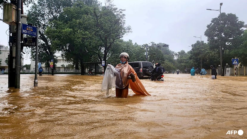
An emergency situation lingers in multiple geographies. Large sections of Central Vietnam have been hit by a seemingly endless deluge of rain that have flooded up to 200,000 homes and killed at least 90 people.
The country has been hit by 14 typhoons this year. And storms have impacted major urban centres and tourism hotspots nationwide, from Hanoi and Hue in the north, to Danang, Hoi An and Nha Trang, and Ho Chi Minh City in the south, causing hundreds of millions of dollars in damages.
Multiple river basins experienced exceptionally severe floods, with water levels surpassing historical records, including the Huong, Vu Gia–Thu Bon, Ba and Dinh rivers. The city of Hue received record rainfall of 1m to 1.7m in a 24-hour period in late October.
“The simultaneous occurrence of extreme, record-breaking floods across several independent river systems strongly underscores the abnormal nature of this event,” said Pham Thi Thanh Nga, the director-general of the Vietnam Institute of Meteorology, Hydrology and Climate Change.
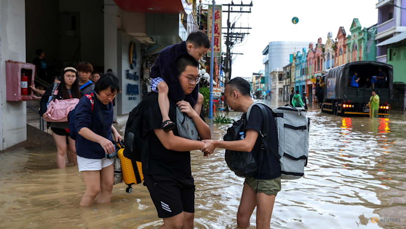
The death toll is climbing as tens of thousands of people across Southeast Asia deal with record-breaking rain. Thailand is reporting more than a dozen dead. In Malaysia, authorities are scrambling to find safe housing for more than 18,000 people. Meanwhile in Vietnam, nearly 100 people have died due to the most severe flooding in decades.
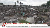
In the Philippines, successive typhoons - Kalmaegi and Fung-wong - battered the central Philippines this month, bringing destructive winds, torrential rain and widespread flooding to a region weary from a spate of disasters.
More than 1.5 million people were evacuated over both events, the 20th and 21st typhoons to hit the country this year.
“Fung-wong was rather incredible. It was a super typhoon. And the size made it look like it was engulfing the whole country,” said Fredolin Tangang, climate scientist and emeritus professor at the National University of Malaysia.
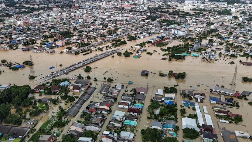
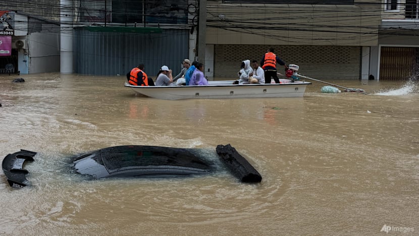
Meanwhile, in Thailand, a mass evacuation was ordered around the municipality of Hat Yai and a disaster zone was declared, following the heaviest single-rain in the area in three centuries.
More than 600 mm of rain hit the area in a matter of days, cutting off the southern region’s economic hub, leaving tourists stranded and forcing temporary evacuation centres to serve the displaced.
One Malaysian family visiting from Kedah recounted on social media being rescued by a humanitarian organisation, United Sikhs, after being caught by the floodwaters.
“We were really very, very trapped in the hotel. The water was really rising. We were desperate for food. There was no electricity,” said one of the rescued women.
The devastation stretches across nine southern provinces, including Songkhla - home to Hat Yai - with an estimated 2.1 million people affected.
With the full onset of the northeast monsoon already bringing early widespread flooding, Malaysian authorities are also on alert and now monitoring more than 3,000 flood hotspots, with eight states already inundated.
On Wednesday (Nov 25), nearly 25,000 people were in shelters, according to official data.

MOISTURE AS FUEL
Twin drivers that rarely coincide so strongly have combined to turn swathes of the region into a moisture engine, experts said.
“Moisture is fuel for extreme rainfall. Simple as that,” Tangang said.
The La Niña phenomenon - when cooling in the central Pacific shifts heat westward, strengthening monsoon rains across maritime Southeast Asia - has lingered for the last few months.
While it has not been strong compared to previous years, it has been enough to boost rainfall and enhance monsoon patterns, especially when combined with a negative Indian Ocean Dipole.
This climate pattern is characterised by warmer-than-normal waters near Indonesia, which draw in moisture and amplify regional precipitation.
These two events do not normally peak at the same time because they arise from different ocean basins, driven by unique circulation patterns and generally varied seasonal timings.
Nga noted a “striking contrast” this wet season; although sea surface temperatures in the central Pacific have cooled, waters in the South China Sea off Vietnam’s east coast and the eastern Philippines sea have remained abnormally warm.
The result? “Ideal conditions for storms to produce exceptionally intense rainfall,” she said.
In addition, global warming is a contributing factor to the power of the storms. Last year was the hottest year on record, where globally temperatures were about 1.55 degrees Celsius above pre-industrial levels, according to the World Meteorological Organization (WMO).
“It definitely has an effect on how much moisture the atmosphere can hold, and eventually this turns into heavy rainfall, flooding, landslides, you name it,” Tangang said. Warmer air holds more moisture, which in turn leads to heavier and more intense rainfall.
Asia is “warming nearly twice as fast as the global average”, the WMO said last year in its State of the Climate in Asia report.

There are other broader factors at play too. Weather events are not only influenced by local temperature conditions but by regional ones, said Zelina Zaiton Ibrahim, an associate professor at the Faculty of Forestry and Environment at Universiti Putra Malaysia.
Therefore, monsoon winds blowing over Malaysia are affected by temperature variations in China and Australia, she explained.
La Niña is expected to persist through early 2026. The risk of abnormal rainfall may continue into the early new year, although the pattern is expected to be irregular, Nga said.
Already water-saturated soils mean even moderate rain could cause further floods or landslides.
The ASEAN Specialised Meteorological Centre noted that rainfall is predicted to be above normal for this time of the year for much of southeastern mainland Southeast Asia, as well as parts of the Maritime Continent - which includes the archipelagos of Indonesia and the Philippines, as well as the Malay Peninsula - over the next few months.
GREATER PREPAREDNESS NEEDED
The long-term outlook for the region is problematic due to climate change, experts said. Weather events and disasters that were considered rare or historic in the past are now common occurrences.
“This leaves communities with very limited reaction time, while a portion of the population remains unprepared or underestimates the risks,” Nga said.
Typhoons, while not expected to increase in number in the years to come, are increasing in intensity, according to climate science.
Rainfall is expected to become more erratic, with shorter return periods for extreme events and higher compound risks, adding stress to countries’ weather forecasting systems.
Governments in this region should be investing more in climate adaptation to minimise the impacts, as well as enhancing resilience to such events in future, Tangang said.
Climate adaptation measures can include upgrading canal and drainage networks, increasing green infrastructure like natural water retention and absorption areas, coastal protection, smart forecasting and investments in community preparedness.
In Vietnam, Nga stressed the importance of strengthening local technical capacity, improving public awareness and ensuring that communities can adapt to a rapidly changing climate.
Adaptation was a major agenda item at COP30, the recent United Nations-led climate talks. Parties agreed to triple adaptation finance by around 2035, but a lack of clarity over the details left many developing countries bitter at the result.
Countries in Southeast Asia may get greater financial support in future but the delay in scaling up means current adaptation gaps remain exposed. Governments are struggling to keep up as the magnitude of impacts grow and finance delivery remains sluggish and uncertain, Zelina said.
The flooding in Hat Yai was an example of a crisis unfolding faster than Thailand’s adaptation measures could cope with, said Seree Supratid, director of the Center for Climate Change and Disasters at Rangsit University.
But still, he argued, more could have been done at a national level to plan for such a situation.
“The severity of the impact stems from insufficient planning and a delayed response. If the national disaster management plan had been fully implemented, the situation would not have escalated to this level,” he said.
On Tuesday afternoon, Thai Prime Minister Anutin Charnvirakul invoked an emergency decree for Songkhla province which includes Hat Yai and directed the defence force to take charge of relief efforts.
Local authorities in Hat Yai had raised a red-flag alert and noted that floodwaters had reached critical levels last Friday (Nov 21).
Rescue missions by Malaysian volunteer teams to evacuate their countrymen stranded in Hat Yai are ongoing, Malaysian news outlets reported on Monday and Tuesday.
The Malaysian Meteorological Department on Tuesday issued a Continuous Rain Warning (Danger) until Wednesday for several districts in Kelantan and Besut in Terengganu.
It issued a Continuous Rain Warning (Severe) until Wednesday for the entire states of Perlis, Kedah and Penang, as well as several areas in Perak, Kelantan and Terengganu.
King Sultan Ibrahim Sultan Iskandar also ordered temporary relief centres to ensure basic amenities, food and medical aid are sufficient for evacuees.
For now, emergency responses are the main priorities for authorities under strain to protect and shelter their populations.
But experts warned that a deeper challenge remains: To try and ensure that the next season of inevitable storms hits a region better prepared than it is right now.
“This is a vulnerable region with less adaptive capacity, and of course, that drives the impacts getting worse in the future,” said Tangang of the National University of Malaysia.
“This is not easy to fix, because climate change works on a global scale.”